The Román River: water, mills and heritage in Valdeprado
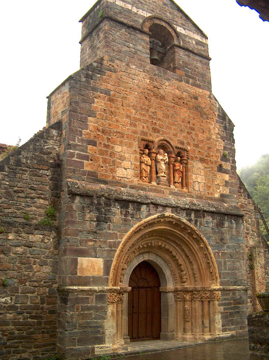
Portal of Santa María de Piasca, in the valley watered by the Román River. Photograph by AnTeMi, published on Wikimedia Commons under the CC BY-SA 3.0 licence. This is a contextual heritage image, not a photograph of the river. File, author and licence.
The Román River is a watercourse in Liébana that crosses Valdeprado, within the municipality of Cabezón de Liébana. It is a small, local river linking the valley slopes and rural hamlets with Piasca and the floor of the Bullón valley. Municipal planning documents recall that its water irrigated fields and powered several flour mills, now gone. Alongside this history of water-powered work, the river runs by one of the comarca’s most notable heritage sites: Santa María de Piasca.
The river should not be confused with other places in Cantabria named San Román. This guide covers only the Román River mapped in Valdeprado and associated with Piasca, Ubriezo and the Bullón system.
Headwaters and course
The sources consulted do not identify a named spring or give coordinates for a single point of origin. A 2013 municipal report on Ubriezo’s water supply says that the intake at the time drew from a small spring beside the Román, upstream from Piasca. This places a spring in the upper reaches but does not establish it as the river’s hydrological source. The headwaters are therefore best understood as the small contributions from the slopes of upper Valdeprado, without assigning the river to a specific spring.
From the upper valley, the stream descends towards Piasca. The village lies on a hillside at around 556 metres above sea level, and the church of Santa María la Real stands beside the river, according to the Encyclopaedia of Romanesque Art. The Román then flows into the Bullón, which in turn reaches the Deva at Ojedo. A study by Jesús Ruiz Cobo and Ana Rubio Celemín on the monastery of Piasca likewise describes the Román as a tributary of the Bullón running through Valdeprado.
The Government of Cantabria’s General Hydrographic Network maps the Román as a line approximately 3.08 kilometres long. This is the length calculated from the mapped centreline; it is not a field hydrology measurement and may not include every small headwater stream. It conveys the river’s scale, not that its entire course can be walked along a riverside path.
Tributaries and connection with the Bullón
No reliable list of named tributaries flowing directly into the Román has been found. In a small valley such as this, the river gathers water from springs, minor streams and slope runoff, especially in rainy periods, but the maps and documents reviewed do not give these watercourses confirmed names or a hierarchy. Streams belonging to other Valdeprado valleys or to the Bullón itself should not be attributed to the Román.
The Bullón is the main collector in this sub-basin. It receives the Román and flows down towards Cabezón de Liébana, Frama and Ojedo, where it joins the Deva. The Vendejo River ES, although also part of the Bullón system, drains a different valley upstream and is not a tributary of the Román. For the wider network, see the Bullón River guide ES and the Deva basin guide.
Official mapping also records streams and small watercourses around Piasca and other settlements in the municipality. Their proximity alone is not enough to assign them to the Román: they should only be listed as tributaries when a hydrological or local source confirms their confluence.
Places to visit beside the river
Piasca and Santa María la Real. The main reason to stop in the valley is the Romanesque church of Santa María la Real, declared a National Monument in 1930 and protected as an Asset of Cultural Interest (BIC). The church stands in a small valley among orchards and trees, beside the Román. Its portal and Romanesque sculpture make it one of the most rewarding heritage visits in Cabezón de Liébana. The town council recommends taking the turn-off to Piasca from the CA-184 and visiting the church; opening times and access can vary, so check ahead.
The river’s relationship with the monument is also part of the local landscape: its water irrigated orchards and formed part of everyday life in the community. Municipal records from 2004 say that it powered several flour mills. Those mills had disappeared by the time the document was written, so they are presented as historic water-related heritage, not as surviving buildings open to visitors.
Ubriezo and the upper valley. Ubriezo is a useful reference point for understanding the upper reaches. In 2013, a water-supply project described an intake beside a spring on the river upstream from Piasca and noted that its flow was insufficient in summer and on weekends for the seasonal population. This is information about the water system at that time, not evidence that the intake is still operating or accessible. Do not enter water-supply facilities or private land.
Paths around the former Piasca council area. The town council describes routes through Piasca and the rural settlements that belonged to its former council area, including Ubriezo, Aceñaba, Los Cos and Yebas. They offer a way to discover traditional buildings, orchards, old hamlets and hillside scenery. The available information does not confirm a waymarked trail following the whole Román or continuous recreational access to its banks. Ask the town council about path conditions before setting out; use public roads and paths and respect private land and water intakes.
The Bullón valley. To extend the visit, continue along the CA-184 towards Cabezón de Liébana and Frama. The municipal route highlights Bullón scenery, churches, traditional architecture and other waterways in Liébana. This gives context to the Román within its basin, but should not be described as a riverside walk along this particular stream.
A small river in a worked landscape
The Román shows how a stream only a few kilometres long can shape valley life: it supplies water to orchards, runs by hamlets and preserves the memory of flour mills. The area also contains an outstanding monument at Santa María de Piasca. The most reliable way to explore it is to combine Piasca with the public paths around the former council area, keeping the distinction clear between the river landscape, vanished water-powered heritage and access that is actually available.
The headwaters remain the point requiring further research. Sources place a spring beside the stream above Piasca but do not identify it as the river’s source. Nor has a list of direct tributaries been verified. Making this uncertainty explicit avoids turning approximate references into falsely precise facts.
Sources
- Government of Cantabria, General Hydrographic Network, layer 294: Román River feature, ObjectID 325; mapped centreline approximately 3.08 km.
- Spain’s Official State Gazette (BOE), Decree 159/2003 on the protected setting of Santa María de Piasca: confirms BIC status and inclusion in the National Artistic Heritage Monument Catalogue in 1930.
- Encyclopaedia of Romanesque Art, Piasca, Cabezón de Liébana: places Santa María de Piasca beside the Román and describes the monastery’s historic setting.
- Government of Cantabria, Cabezón de Liébana planning regulations, Cantabria Official Gazette, 18 November 2004: records that the river irrigated Piasca and powered several flour mills, since disappeared.
- Jesús Ruiz Cobo and Ana Rubio Celemín, “The monastery of Piasca (Cabezón de Liébana, Cantabria) in the Modern Age: archaeology and economy”, Sautuola XXIX (2024), pp. 149–163, digital edition from the Sautuola Institute: describes the Román as a tributary of the Bullón crossing Valdeprado.
- Valle de Liébana, water supply in Ubriezo: places a small intake spring beside the river upstream of Piasca; it does not identify it as the source.
- Cabezón de Liébana Town Council, routes around the municipality: access to Piasca and Santa María, settlements of the former council area and rural architecture.
- Contextual photograph: AnTeMi, Piasca1.jpg, portal of Santa María de Piasca; CC BY-SA 3.0 licence. The image does not show the river.