Suances Harbour: Maritime History, Fish Market and Estuary Walk
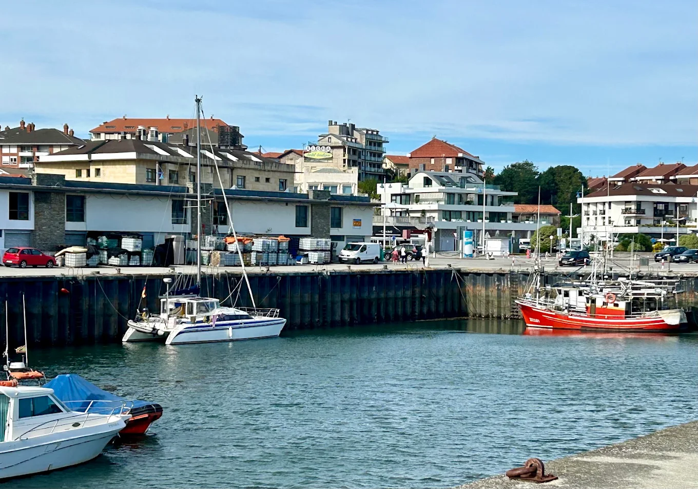
Suances harbour is one of the places that best explains the town’s relationship with the sea. It lies beside the mouth of the San Martín de la Arena estuary, between La Ribera and La Riberuca beaches, and retains a small fishing area alongside berths for leisure and recreational craft.
This is not a large commercial port or a marina designed for sizeable vessels. Its interest lies precisely in its scale: the fishing boats, fish market, Fishermen’s Guild, gear, tides and daily activity recall that Suances was a port long before it became one of the leading tourist destinations on the Cantabrian coast.
You can extend your visit with a walk along La Ribera, up to the La Cuba viewpoints, on to La Concha beach and out to Punta del Dichoso. In the late afternoon, the harbour offers one of Suances’s best-known scenes, with boats reflected in the basin and the estuary opening towards the Bay of Biscay.
Suances harbour at a glance
- Name: Suances harbour
- Historic name of the area: Port of San Martín de la Arena
- Town and municipality: Suances, Cantabria
- Location: West bank of the San Martín de la Arena estuary, beside La Ribera
- Approximate distance from the estuary mouth: About 600 metres
- Type: Regional port with mixed uses
- Main uses: Fishing and recreational boating
- Layout: Fishing area to the north and leisure area to the south
- Inner water area: Approximately 10,000 m², according to 2025 port records
- Historic pier: Designed in the first third of the 20th century and completed in 1937
- Modern layout: Piers and the basin’s first dredging works carried out in 2001
- Fishing organisation: Fishermen’s Guild of Our Lady of Mount Carmel
- Main maritime festival: Our Lady of Mount Carmel, 16 July
- Visit: Public exterior and harbour walk; working areas are not tourist spaces
Where is Suances harbour?
The harbour lies in the lower part of Suances, on the western bank of the San Martín de la Arena estuary. It occupies the area beside the sandy stretch of La Ribera and is close to La Riberuca, the Marina promenade and the local restaurants and cafés.
The basin is about 600 metres from the estuary mouth. From the piers, you can see the Miengo bank, intertidal sandflats, the entrance to the Bay of Biscay and, in different directions, the slopes of La Cuba and Punta del Dichoso.
The location makes the harbour a useful starting point for exploring the town on foot. From here, head towards La Concha beach and the lighthouse, climb to the old fishing quarter of La Cuba or follow the foot and cycle path beside the estuary towards Hinojedo and the Saja-Besaya basin. To make the climb to the upper town easier, the Town Council has a planned funicular ES between this area and Quinta del Amo, although it has not yet been built.
Harbour, estuary and pier: three different things
Tourism information often uses Suances harbour, the Port of San Martín de la Arena, the pier and the estuary as if they were interchangeable. They are related, but they do not mean exactly the same thing.
- The San Martín de la Arena estuary is the tidal inlet formed at the end of the Saja-Besaya river system before it reaches the Bay of Biscay.
- The Port of San Martín de la Arena is the historic name for the harbour site developed within this estuary.
- Modern Suances harbour is the basin on the western bank, with fishing and leisure areas.
- A pier is one part of port infrastructure, used for mooring, unloading and other operations.
This distinction also helps avoid confusing Suances harbour with nearby sites. Requejada harbour is farther upstream in the municipality of Polanco; La Pozona lies on the Miengo bank; and Puerto de Los Cantos ES is a small traditional boat shelter at another point on the Suances shoreline.
Why visit the harbour?
The harbour is notable less for monumental architecture than for bringing together several essential parts of Suances in a small area:
- A fishing tradition documented since at least the Middle Ages.
- The relationship between the town and the San Martín de la Arena estuary.
- Professional and recreational boats sharing the harbour.
- The fish market and Fishermen’s Guild.
- The legacy of fishers, sardine sellers, net makers, caulkers and other maritime trades.
- The festival of Our Lady of Mount Carmel and its maritime procession.
- Connections to the beaches, walkways and old fishing quarter of La Cuba.
It is a good place for a walk, photographs and watching the estuary change with the tides. It also helps explain that Suances’s tourist landscape grew from a much older port history.
The possible link with the Roman Portus Blendium
Suances is traditionally identified with Portus Blendium, the port of the Blendii mentioned in ancient sources. Pliny the Elder refers to this place, and the so-called Brick Itinerary records a road connecting the interior with a port of that name on the Cantabrian coast.
Modern research generally places it around Suances and the San Martín de la Arena estuary. Roman-era remains have been found near the parish church, including building materials, coins and pottery from the first and second centuries. These finds confirm significant Roman occupation, consistent with a settlement linked to maritime traffic.
However, it should not be stated that today’s basin occupies the exact site of the Roman pier, or that any specific point has been archaeologically proven. Ancient port facilities may have stood elsewhere along the shore, and the estuary’s landscape has changed through sedimentation, tides and centuries of engineering works.
The most accurate wording is that Suances and its estuary are generally associated with Portus Blendium, while the precise location of the Roman port facilities remains under study.
From Suancies to the Port of San Martín de la Arena
The earliest written reference to the town’s name appears in a document in the Cartulary of Santillana, dated 870, which mentions a village called Suancies.
During the early Middle Ages, Suances and its port were linked to the Abbey of Santillana. Fishing is documented at least from the 12th century, when the Port of San Martín de la Arena was already an important site for communities along Cantabria’s central coast.
The name San Martín came from an old religious dedication and eventually referred to both the estuary and the port. The name endured for centuries and remains in the estuary’s official name today.
Medieval navigation did not take place in a basin like the present one. Boats used the estuary’s natural shelter, sandflats and places where they could be beached, loaded or unloaded according to the tides.
Medieval fishing and whaling
Fishing was one of Suances’s main historic resources. Heritage sources refer to seasonal fisheries for sardines, sea bream, conger eel and other species, as well as whale hunting.
Whaling was important at many Cantabrian ports during the Middle Ages and early modern period. Whales provided blubber for oil, baleen and other materials with commercial value.
Suances had a building known as the House of the Whales, which stood until 1880. Popular historical accounts say it was demolished to make way for an inn serving visitors who were beginning to arrive for sea bathing.
This episode captures the town’s transformation: a place associated for centuries with using marine resources was beginning to adapt to a new economy built around summer visitors.
The Tower of San Martín de la Arena
In the Late Middle Ages, control of the port had considerable economic and strategic importance. The powerful de la Vega family, one of the leading noble houses of the Asturias de Santillana, exerted influence over Suances and clashed with the town of Santander over control of port activity.
In this context, the Tower of San Martín de la Arena was built in the early 15th century. It was a seigneurial fortification intended to control the site and its commercial movements.
The tower has disappeared and should not be confused with the coastal defences at El Torco, nearer the estuary mouth. Old photographs and references evoke a harbour landscape where boats were beached near the medieval building, before modern piers existed.
Commercial growth in the 16th, 17th and 18th centuries
From the 16th century onwards, Suances harbour developed a busy trading role. The Town Council identifies the 17th and 18th centuries as its period of greatest prosperity.
The estuary connected the coast with the Saja-Besaya valley and a broad inland area. The port moved goods, supplied settlements and linked the region with other parts of the coast.
Fishing went hand in hand with related trades. Suances had facilities for pickling fish, basket-making workshops that produced containers, boatbuilding and repair, and caulking work to keep wooden hulls watertight.
The harbour should therefore be understood as a small economic system. Each boat supported sailors, owners, unloaders, sellers, craftspeople and families who prepared or marketed the catch.
The Fishermen’s Guild of Our Lady of Mount Carmel
In 1695, the bylaws of the Suances Fishermen’s Guild of Our Lady of Mount Carmel were approved. This shows that the maritime community had its own organisation during the port’s most active period.
Fishermen’s guilds regulated essential aspects of maritime work: organising fishing, mutual aid, sales, support for families and representation before other authorities.
The Fishermen’s Guild of Our Lady of Mount Carmel still appears in the official directory of organisations linked to Cantabria’s ports, and its headquarters are on Calle El Muelle.
Visitors should remember that the guild is a professional organisation, not a tourist attraction. Access to its offices and operational areas depends on its work and on receiving permission.
Sardine sellers and the women of the harbour
Maritime history cannot be reduced to the people who went fishing. Women took part in unloading, preparing, selling and carrying fish; mended nets; managed household finances; and sustained daily life while sailors were away.
Sardine sellers carried and sold fish, walking the streets and markets with loaded baskets or containers. Their work linked the pier directly with customers.
The Sardinera monument in the harbour area recalls this work. It depicts a woman with a basket of sardines and a boat at her feet. More than a decorative feature, it honours an essential part of the maritime economy that long remained less visible.
When photographing the sculpture, include the harbour or estuary in the frame. This makes the relationship between the figure and the landscape where she worked easier to understand.
The modern pier project
Until well into the 20th century, many Suances boats depended on beaching and the estuary’s natural conditions. The need for a permanent pier led to several proposals.
An early option would have placed it in the Portucho inlet near La Concha beach. The project’s cost and technical difficulties led to a review of that location.
In 1920, plans shifted to the sands of La Ribera, near today’s Sardinera monument. The pier project was completed in 1937, followed by supporting facilities including a shed and a fish-weighing scale.
The date 1937 refers to the modern historic pier; it does not mean that the entire basin visitors see today was built then. The harbour underwent expansions, renovations, dredging and new works over the following decades.
The harbour’s modern layout
Government of Cantabria records state that the basin’s initial dredging and construction of its modern piers took place in 2001.
The harbour was configured as a mixed-use facility for fishing and leisure or recreational boats. This division still shapes the space today.
The result brings together infrastructure from different periods:
- The memory of the sandy shore and old places where boats were beached.
- The fishing pier planned in the first third of the 20th century.
- Buildings and services added later.
- The basin and piers reorganised at the start of the 21st century.
It would be inaccurate to assign one single date to the whole harbour. Its current appearance reflects a long process of change.
How the harbour is laid out today
According to technical figures published in 2025, the inner basin has approximately 10,000 square metres of sheltered water.
Fishing area
The northern sector, with around 3,750 square metres of water, is reserved for fishing. Professional boats moor and unload their catch here.
Its reference depth is greater than that of the leisure area. Technical figures can change after sediment builds up or dredging takes place; they should not be used to plan a sea passage without checking official nautical information.
Leisure and recreational area
The southern sector covers around 5,000 square metres and is used by leisure and recreational boats.
These boats reflect the changes in Suances and the growth of recreational boating. However, the harbour should not be described as a large marina or as a facility designed for very large vessels.
Access channel
A channel connects the basin entrance to the inner areas. Navigation depends on depth, tides, sedimentation and port instructions.
Those arriving by sea should use official charts, notices and navigation markers. A visitor guide cannot replace nautical information or guarantee conditions on a particular day.
Why the harbour needs regular dredging
The port lies within a dynamic estuary. Rivers carry sediment, while tides redistribute sand and mud. Some of this material settles in the basin, gradually reducing its available depth.
For this reason, the port authority carries out bathymetric surveys and maintenance dredging. Further campaigns were recorded in 2007, 2012 and 2017 after the initial works in 2001.
In 2025, the Government of Cantabria launched another project to restore depths in the fishing, leisure and access areas. It planned to remove 10,562 cubic metres of sediment across an area of approximately 10,000 square metres.
These are not simply cosmetic works. They are needed to keep the harbour operational and vessels safe. They also explain why the water, seabed or some areas of the port may look different for a time.
The Suances fish market
The fish market is one of the buildings most closely linked to the harbour’s fishing role. Facilities of this kind organise the receipt, inspection and first sale of catches, alongside related operations.
Its activity depends on fleet arrivals and professional arrangements. Do not assume there is a public auction, free visitor access or direct fish sales without first checking how it currently operates.
From outside, the fish market helps explain the traditional journey of seafood:
- The vessel reaches the harbour.
- The catch is unloaded and sorted.
- Relevant checks and sales procedures take place.
- The product goes to fishmongers, markets, restaurants or other outlets.
The fish market is a workplace. Unloading areas must remain clear, and any visit inside requires permission.
A small, working fishing harbour
Suances has a modest fleet compared with Cantabria’s major fishing ports. Its size does not diminish its cultural importance or the work it supports.
Boats, gear and catches change with the seasons, regulations and the industry. For that reason, old figures for vessel numbers or landed tonnage should not be presented as current.
The best way to understand the harbour is to see it as a working place. Some days bring unloading and maintenance activity; at other times it is much quieter.
Professional work takes priority. Visitors should stay on public routes and keep away from cranes, ropes, vehicles, wet work areas and mooring manoeuvres.
Our Lady of Mount Carmel and the maritime procession
The feast of Our Lady of Mount Carmel, patron saint of sailors, takes place on 16 July and is one of the most important dates in Suances’s calendar.
The image is carried in procession to the harbour and placed aboard a boat for a trip through the estuary, accompanied by other decorated vessels. The celebration brings together religious devotion and remembrance of those who work or have died at sea.
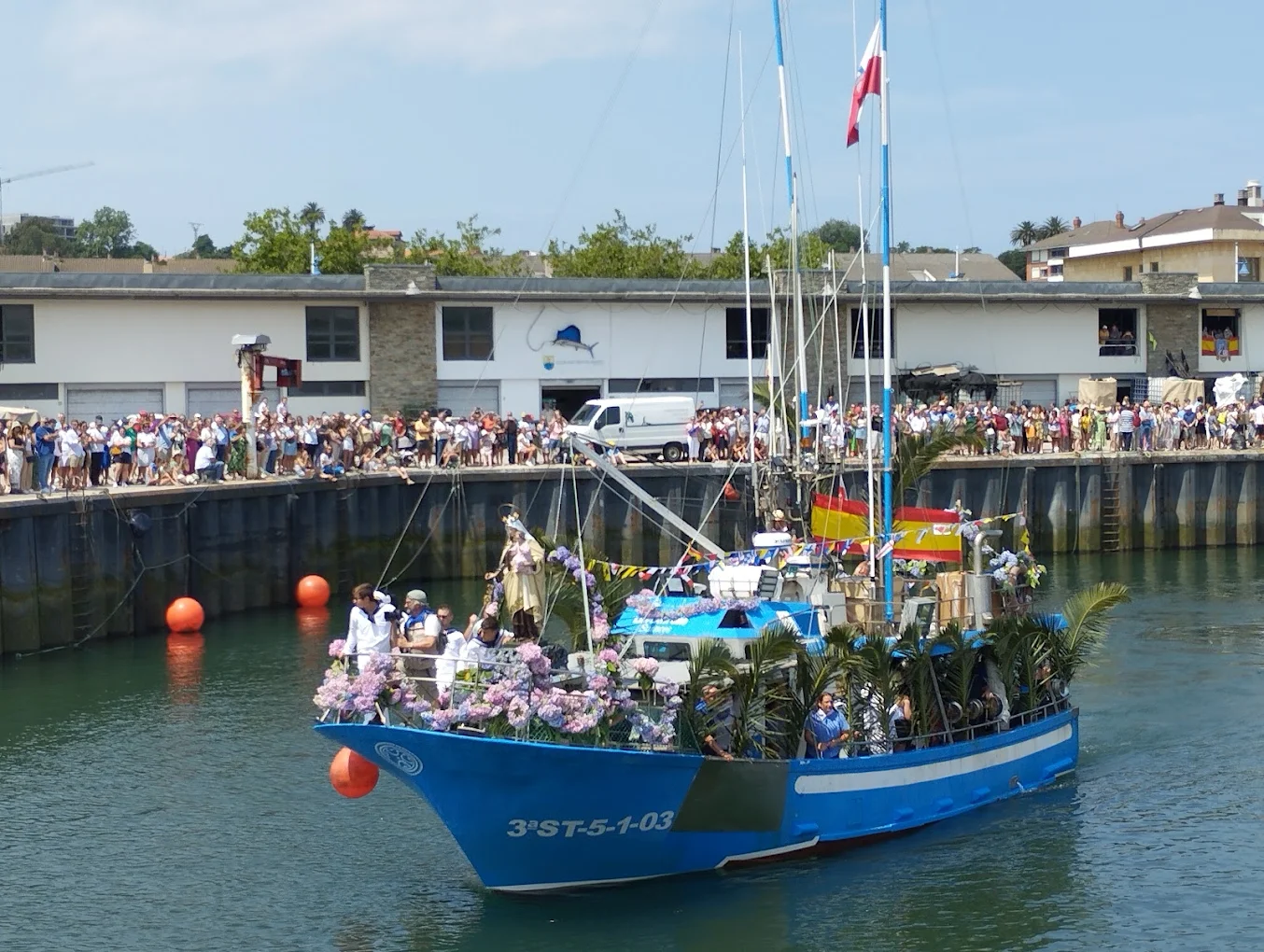
The harbour becomes a large gathering place that day. Residents, fishers and visitors come to watch the departure, take part in events and keep alive a tradition closely tied to local identity.
The programme, timetable, route and sea conditions vary each year. Before travelling, check information from Suances Town Council or the local tourism office.
What to see at Suances harbour
Fishing boats
They best preserve the maritime character of the harbour. Their size, colours, gear and equipment distinguish them from recreational craft.
Do not board, touch fishing gear or enter mooring areas. You can observe from public routes without interfering with work.
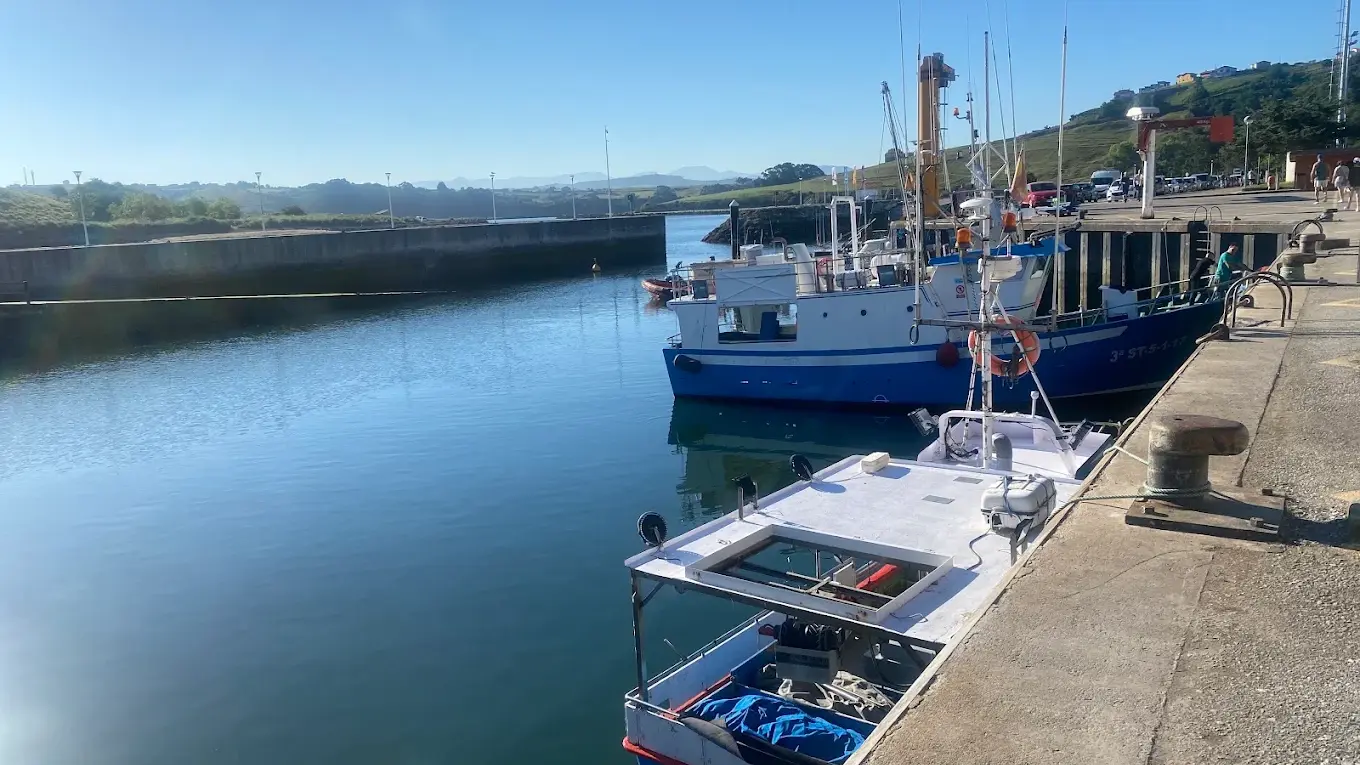
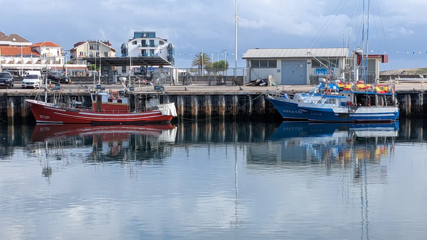
The leisure basin
The southern sector holds small recreational craft. The contrast between the two areas illustrates the harbour’s mixed use.
Mooring arrangements may change, and some access points may be restricted. A pontoon is not necessarily a public walkway.
The fish market and Fishermen’s Guild
Both are part of the economic and social organisation of fishing. Although their interiors are not normally part of a tourist visit, their location matters on an interpretive walk.
The Sardinera monument
The sculpture honours the women who carried and sold the catch. It is a good starting point for explaining that harbour history was also made on land.
La Ribera beach
La Ribera beach lies immediately beside the harbour. Facing the estuary, it has a different landscape from the beaches open to the Bay of Biscay.
Check the town’s seasonal information for bathing conditions, facilities and accessibility.
La Riberuca
La Riberuca extends into the estuary, where broad intertidal flats appear at low tide.
It is a good place to watch birds and understand how the estuary works. Rules for animals and other conditions may change, so check the current regulations.
The estuary mouth
From the harbour, you can see the opening towards the Bay of Biscay. The entrance is visually protected by the lighthouse area and the old defences at El Torco.
Waves outside may be strong even when the basin looks calm. This difference helps explain the importance of the harbour’s shelter.
Suggested walks from the harbour
A short walk along La Ribera
A brief visit can start by the Sardinera monument, follow the public side of the basin, take in the fish market and continue along La Ribera beach.
This is an almost level walk and a good way to see the area without going far from the harbour. Depending on stops, it takes about 30 minutes.
From the harbour to La Concha
Follow the Marina promenade to La Concha beach. The route links the fishing landscape with Suances’s main urban beach.
You can continue towards Punta del Dichoso, Suances lighthouse and El Torco. The total distance depends on where you turn back.
Climb to the La Cuba viewpoints
The La Cuba viewpoints offer one of the best panoramas of the harbour, estuary and inner beaches.
The climb is steep and can be made by several streets or by the restored Fuente de Enmedio Shortcut. Sailors once used this historic path to reach the harbour, and women used it to get to the washhouse.
Path beside the estuary
A foot and cycle path begins near La Riberuca and follows the estuary towards Hinojedo. It forms part of a wider route network associated with the Saja-Besaya Green Arc.
It is a good option for walking or cycling away from the busiest tourist area. Choose a distance to suit your time and return along the same route.
The old fishing quarter of La Cuba
La Cuba occupies the hillside above the harbour and preserves the memory of Suances’s old fishing quarter. Its streets, slopes and viewpoints show how closely homes were tied to the workplace.
From higher ground, sailors could check the estuary, sandbar and sea before heading out. The three improved viewpoints retain this visual role and make the landscape easier to understand at a glance.
A visit to the harbour is much more complete when seen again from La Cuba. Below, you notice details of the boats and facilities; above, you understand how the whole site fits into the estuary.
The estuary as a natural environment
The San Martín de la Arena estuary is more than a navigation channel. Tides shape this inlet, with sandflats, mudflats and marsh areas where many birds feed and rest.
At low tide, broad intertidal areas are exposed. At high tide, the landscape changes as water fills channels and edges that looked like dry land only a few hours earlier.
This cycle affects navigation, fishing, the harbour’s appearance and wildlife. It also calls for care: do not walk across muddy flats, attempt to cross channels or reach islets and sandbanks without knowing the tides.
Use binoculars to watch birds, keep your distance and avoid noise. Public walkways offer enough places to observe without disturbing wildlife resting areas.
Where to take the best photographs
From the harbour promenade
Get close-ups of boats, reflections and working details. Morning light often falls well on some buildings and vessels, although the direction varies along the quay.
From La Ribera
The beach gives a side view of the basin and shows how the harbour, sand and estuary fit together.
From the La Cuba viewpoints
This is the best all-round panorama. From above, you can see the harbour’s two areas, the inner beaches, the Miengo bank and the estuary mouth.
At sunset
Low light brings out the boats’ outlines and can create reflections on the water. The sun’s position changes with the seasons, so the best composition will not always be the same.
During fishing or unloading, take photographs from public areas and respect workers’ privacy. Ask permission for professional photography, interior shots or identifiable close-ups.
Where to eat near the harbour
The harbour area and seafront have many places to eat. Options include fish and seafood, Cantabrian dishes, shared plates and more casual meals.
Being near the fish market does not guarantee that all fish served comes from Suances or was landed that day. If the origin matters to you, ask the restaurant.
In high season and at weekends, book ahead and check opening times before setting out.
Getting there
Reach the harbour through the lower part of Suances by following signs for the beaches and seafront. The main access connects with La Ribera, La Concha and Avenida de la Marina.
Traffic can be heavy in summer, during festivals and on fine-weather days. Allow extra time, follow signs and consider walking from another part of town.
Do not park in spaces reserved for port operations, loading areas, fish market access, ramps, emergency exits or berth users.
Accessibility
The public promenade near the harbour and La Ribera has level sections, but works, street furniture, crowds and illegal parking can affect access.
Professional areas, pontoons and boats should not be assumed to be open or accessible to the public. Do not rely on specific accessible parking spaces unless current signs confirm them.
The climb to La Cuba is steep. For a panoramic view with less effort, look for a road access to the viewpoints and check parking conditions first.
Safety advice
- Stay on walkways and in areas open to the public.
- Keep clear of unloading and manoeuvring zones.
- Keep children away from the edge of the piers.
- Do not touch ropes, nets, boxes, cranes or machinery.
- Watch for wet and slippery surfaces.
- Do not enter closed or reserved pontoons.
- Check the tides before walking around intertidal areas.
- Follow instructions from port staff and emergency services.
- Do not obstruct professional vehicles.
- Take extra care during storms or strong gusts.
The harbour is a workplace beside the water. A railing or paved surface does not remove the risk of falling.
What to see near Suances harbour
La Concha beach
The town’s main urban beach is a short walk along the seafront. Its broad bay contrasts with the sheltered feel of the basin.
Punta del Dichoso
Punta del Dichoso separates the La Concha area from Los Locos beach and offers some of the town’s best-known coastal scenery.
Suances lighthouse
The lighthouse overlooks the estuary entrance and helps explain navigation conditions along this coast.
El Torco
El Torco preserves old coastal defences built to watch over and protect access to the harbour. The site also serves as a cultural venue and viewpoint.
Los Cantos
Los Cantos is a small boat shelter reached from La Cuba and the estuary path. It should not be confused with the main basin.
Suances town centre
The upper town includes Plaza de Viares, the Town Hall, Nuestra Señora de las Lindes church, Quinta del Amo and other places covered in the guide to Suances history and heritage ES.
Why the harbour is essential to understanding Suances
The harbour brings together more than a thousand years of ties between the community and the estuary. The possible link to Portus Blendium, medieval records, whaling, disputes between noble families, the 1695 guild, commercial growth and the modern pier project form a more complex story than that of a simple landing place.
It also helps explain the town’s economic transformation. Fishing and trade gradually came to coexist with sea bathing, summer visitors and tourism. Today, professional port activity shares the area with recreational boats, beaches, walks and hospitality businesses.
A visit reveals these different layers. This is not a maritime stage set built for tourists, but a small, active facility within one of Suances’s busiest urban landscapes.
Frequently asked questions about Suances harbour
Where is Suances harbour?
It lies on the western bank of the San Martín de la Arena estuary, beside La Ribera beach and close to La Riberuca and La Concha.
Is it a fishing or leisure harbour?
It serves both purposes. The northern area is mainly for fishing and the southern sector for recreational boats.
Can large vessels enter?
This is a small harbour, limited by the depth of the basin and estuary. It is not designed for cruise ships or large commercial vessels.
How is it connected to Portus Blendium?
Suances and its estuary are generally identified with the Roman port of the Blendii. Roman remains have been found in town, but it has not been proven that the ancient pier stood exactly beneath today’s basin.
How long has fishing taken place here?
It is documented at least from the 12th century, although the area’s link with navigation may go back to Roman times.
Were whales hunted in Suances?
Yes. Historic and heritage sources link the medieval port to whaling and mention an old House of the Whales.
What was the Tower of San Martín de la Arena?
A seigneurial tower built in the early 15th century to control the harbour. It has disappeared and should not be confused with the defences at El Torco.
When was the pier built?
The modern pier project was relocated to La Ribera in 1920 and completed in 1937. The present basin and its piers were reorganised through new works in 2001.
Why is the harbour dredged?
River currents and tides deposit sand and mud in the basin, reducing the depth needed for safe navigation.
Can visitors go into the fish market?
Do not assume it is open to tourists. It is a workplace; interior visits require permission or an organised activity.
Can I buy fish directly?
Do not assume direct public sales are available. Sales arrangements depend on the fish market, guild and current regulations.
What is the Fishermen’s Guild?
It is the professional organisation representing and coordinating local fishing interests. Suances’s guild is dedicated to Our Lady of Mount Carmel.
When were its historic bylaws approved?
In 1695, during a period of strong maritime and commercial activity in Suances.
What does the Sardinera monument represent?
It honours the women who carried, distributed and sold fish landed at the harbour.
When is the feast of Our Lady of Mount Carmel?
On 16 July. It often includes a procession by land and sea, though the programme and timings change each year.
How long should I allow to visit?
Thirty minutes to an hour for the basin and La Ribera. Add La Concha, La Cuba or the estuary path to make a longer visit.
Is the area accessible?
Several outdoor sections are level, but check conditions on the day. Pontoons and professional areas are not freely accessible tourist spaces.
Where are the best views?
La Cuba viewpoints offer the broadest panorama of the harbour, inner beaches and estuary mouth.
Which beaches are closest?
La Ribera and La Riberuca are next to the harbour area. La Concha lies further along the seafront.
Is this the same as Requejada harbour?
No. Requejada is farther upstream in the municipality of Polanco. It is also different from La Pozona in Miengo and the Los Cantos shelter.
Can I walk along the piers and pontoons?
Only in areas specifically open to the public. Respect working areas, berths and restricted pontoons.