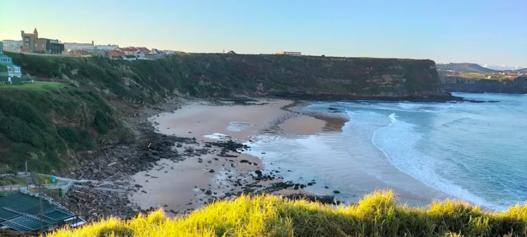
Mioño or Cabrera River: Otañes Valley and Dícido Beach
The Mioño River, also known as the Cabrera River, runs through Otañes Valley in Castro Urdiales and reaches the sea at Dícido Beach. Its basin is separate from that of the Agüera: although the Cantabrian Hydrographic Confederation groups both within the Agüera administrative water-management system, the municipal strategic plan distinguishes their networks and outlets.
Source and course
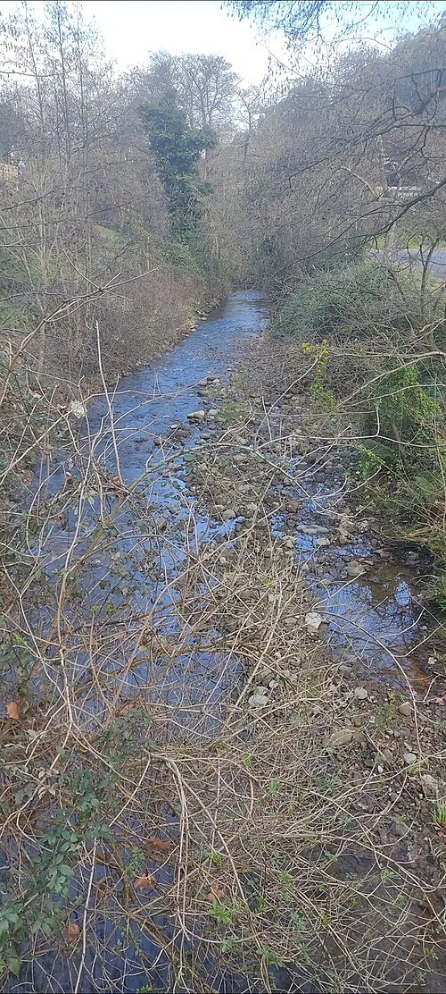
The Cabrera or Mioño River as it passes through Lusa. Photograph by the Lusa Neighbourhood Council, taken on 3 February 2024 and available under a CC BY 4.0 licence. Wikimedia Commons file and reuse details.
Municipal documents identify Otañes Valley as the Mioño River basin and state that the river crosses it towards Santullán, Lusa and Mioño. The regional hydrographic map shows the watercourse as “Río Mioño” and gives it an approximate mapped length of 5.2 km. This figure describes the mapped feature within Cantabria and should not be mistaken for an official measurement of the river’s entire course.
The sources reviewed do not identify a single spring or a precise elevation for the source. This guide therefore places the headwaters broadly in Otañes Valley and leaves the exact spring or initial stretch to be confirmed. The valley is longer than the Sámano Valley, and heritage documents use the names Cabrera or Mioño for the same river.
From Otañes, the river flows down the valley, passing near Santullán and Lusa before reaching the village of Mioño. Its final stretch flows into the small beach of Dícido on the Cantabrian coast. The town council identifies this beach as the mouth of the Cabrera; the municipal plan describes the coastal outlet as a former marsh that has since filled in. The well-known Dícido ore-loading structure, an important part of the area’s industrial heritage, stands near the river mouth.
Tributaries
The Castro-Urdiales 2040 Strategic Plan names two main tributaries in the inner part of Otañes Valley: the Callejamala stream and the Rocalzada stream, also known as the Vados stream. Local maps also use variants such as “Rucalzada” and “Callejamala”. The Otañes Neighbourhood Council describes the Rucalzada as flowing from the slopes of Mount Betaio to the Cabrera weir. This helps explain the valley’s mining and water-management network, but without detailed mapping it does not establish the stream’s precise confluence with the main river.
The municipality describes the Mioño as having a largely naturalised course. In its lower reaches, the growth of Santullán and Mioño and the infrastructure crossing the valley have affected its ecological condition. The municipal document rates it as moderate in the assessment it cites and also identifies it as a protected water body for human supply. These references describe assessments from their respective planning cycles, not a real-time measurement of water quality.
What to see by the river
Otañes and the riverside path
In Otañes, the valley shows how rivers and smaller streams supported traditional uses of water. The Neighbourhood Council explains that the Rucalzada rises on the slopes of Mount Betaio and reaches the Cabrera weir, historically linked to a channel that powered a mill. The area also has a rich mining heritage. Keep to public routes and do not enter mines, tunnels or closed properties.
Santullán, Lusa and Mioño
The municipal guide to neighbourhood councils suggests a path that follows the river to the village of Mioño. There you can see the Church of San Román, the former school and the bandstand. In Lusa, the valley and the Cabrera/Mioño are part of the village’s everyday landscape. Check the condition of paths and local works before setting out, as access and conditions may change.
Dícido Beach and the ore loader
At the river mouth, Dícido Beach brings together the river landscape and Mioño’s industrial coastline. Beside it stands the iron ore loader, known as the Dícido ore loader, a large iron structure associated with mining and maritime transport. The site offers a view of where the river meets the sea. Stay in authorised areas and follow safety notices around the monument and coast.
Related pages
- Agüera basin and coastal watercourses: the administrative management system includes separate basins; the Mioño is not a tributary of the Agüera.
- The town council’s Mioño page describes the riverside path and the village’s heritage sites.
- For the valley’s mining heritage, see the Otañes Neighbourhood Council and the University of Cantabria route. Internal Viajar por Cantabria links are still to be checked in WordPress.
Sources
- Castro Urdiales Town Council, Castro-Urdiales 2040 Strategic Plan, water section: distinguishes the municipality’s rivers, identifies Otañes Valley as the Mioño basin, names Callejamala and Rocalzada or Vados as its main tributaries, and describes the outlet at Dícido.
- Castro Urdiales Town Council, Mioño: neighbourhood councils and places of interest: identifies the Cabrera’s outlet at Dícido Beach and the path alongside the river to Mioño.
- Government of Cantabria, General Hydrographic Network, layer 294: mapped feature named “Río Mioño”, approximately 5.2 km long; this is not a total hydrological measurement.
- Otañes Neighbourhood Council, Natural heritage: describes the Rucalzada, its headwaters on the slopes of Mount Betaio and its arrival at the Cabrera weir.
- University of Cantabria, Castro Urdiales, a seafaring town with iron veins: route: documents the path beside the Cabrera and the mining context of Mioño.
- Official State Gazette, Decree 93/2004 on the protected setting of Cueva Grande de Otañes: uses the name “Cabrera or Mioño River” and places the cave on its left bank.
- Photograph verified against Wikimedia Commons metadata: credited to the Lusa Neighbourhood Council, dated 3 February 2024 and licensed CC BY 4.0. The local image file was inspected; attribution is included in the caption.