The Gandarilla River: its course, Pombo Marsh and the estuary
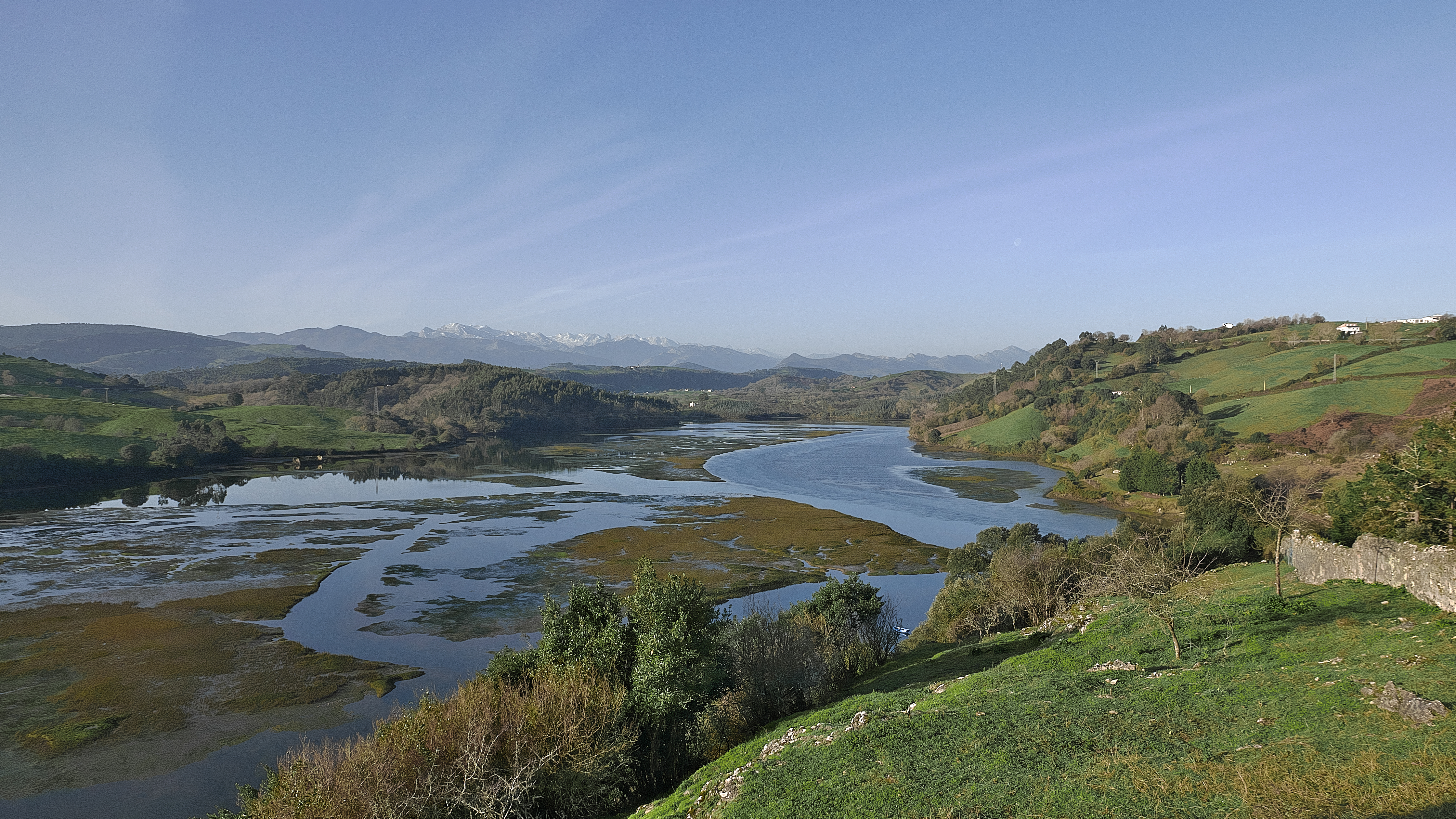
The Gandarilla meets the Pombo marsh, seen from the viewpoint by the church of Santa María de los Ángeles. Photograph by Jl FilpoC, 30 January 2024, CC BY-SA 4.0, Wikimedia Commons file page. The image shows the estuary, not the headwaters or upper channel; it is retained unaltered.
The Gandarilla is a coastal river in the municipality of San Vicente de la Barquera. Its valley links inland meadows and villages with Pombo Marsh, a tidal arm of the San Vicente estuary. The Cantabrian Hydrographic Confederation (CHC) includes it in the Gandarilla water management system alongside the Escudo, Capitán and Turbio rivers. This is a planning grouping; it does not mean that these watercourses are tributaries of one another.
Source and course
The CHC places the Gandarilla’s source on the same side of the mountain range as the Escudo River and estimates its length at 10.3 km. Regional mapping shows a channel of about 10.2 km; the mapped measurement and the figure in the water plan come from different methods and should not be presented as one exact length. The sources consulted do not identify the spring or precise headwater point, or its elevation, so no source coordinate is given here.
The river passes through the area around the villages of Gandarilla and El Hortigal and continues towards the coast. San Vicente’s municipal development plan identifies flood-prone sections: from Gandarilla to El Hortigal and farther downstream, from El Hoyo to Pombo Marsh. This matters when approaching the river: paths and banks can flood, especially during heavy rain and high tides.
In its lower reach, the Gandarilla feeds Pombo Marsh, also called the Brazo Mayor. The Camino Lebaniego educational booklet distinguishes this arm—associated with the Gandarilla and located beyond the Barquera bridge—from Rubín Marsh, connected to the Escudo River and beside the Maza bridge. Both wetlands are part of the San Vicente estuary, but they belong to different channels and tidal arms. This is a tidal landscape: the water’s appearance and extent change with the tide.
Tributaries
No reliable hydrographic source has been found that lists named tributaries of the Gandarilla or confirms a specific confluence with nearby streams. Official mapping connects several watercourses in a provisional network, but endpoint geometry does not establish flow direction or, by itself, prove that a stream flows into this river.
An older popular account of the Escudo River describes the Gandarilla as an Escudo tributary, while Camino Lebaniego material distinguishes their respective estuary arms and the CHC lists them as separate representative courses in the same management system. Based on the available evidence, this guide treats the two as independent rivers and does not classify either as a tributary of the other. Smaller tributaries remain to be verified through further mapping and hydrological review.
Places to visit beside the river
Gandarilla and El Hortigal
The municipal tourist route “San Vicente in Three Days” suggests exploring the inland villages and follows the area around the Gandarilla towards El Hortigal. It highlights the restored hermitage of Santa Ana and the wooded setting of the village. The page describes a tourist itinerary but does not confirm a continuous, waymarked riverside trail: follow the published route and local signs, and do not enter private land or flooded riverbanks.
Santa María de los Ángeles viewpoint and Pombo Marsh
From the viewpoint beside the church of Santa María de los Ángeles, visitors can see the Gandarilla’s mouth and Pombo Marsh. It is a public spot in the historic centre and helps explain how the river valley meets the estuary without entering the wetland. The photograph on this page was taken from this viewpoint.
Barquera bridge and estuary
The Barquera bridge crosses the Gandarilla in its tidal reach. The area forms part of the estuary landscape; use the designated access points and pay attention to tides, signs and environmental restrictions. Walking across the marsh mud or approaching channels at high tide is not recommended.
Oyambre Natural Park
The river mouth lies within the protected Oyambre landscape. You can combine the valley with San Vicente’s villages and coast, while keeping Pombo Marsh distinct from the Rubín arm. Viewpoints and public paths are preferable to walking along banks without an authorised route.
Related guides
- Western coastal basins: Escudo and Gandarilla.
- The Escudo River ES, a separate coastal watercourse that reaches the Rubín arm.
- Pombo and Rubín Marshes: the San Vicente estuary ES, a guide to the estuary.
- San Vicente de la Barquera in Three Days, the municipal tourist itinerary.
Sources
- Cantabrian Hydrographic Confederation, popular guide to the Escudo River: gives a different interpretation by calling the Gandarilla an Escudo tributary; the consulted estuary and basin-system documents do not confirm that relationship.
- Cantabrian Hydrographic Confederation, Western Hydrographic District Plan 2015–2021, Appendix VI.1, Gandarilla system: includes the Gandarilla in the coastal system, estimates 10.3 km and places it on the same mountain slope as the Escudo.
- San Vicente de la Barquera Town Council, General Urban Development Plan, flood-risk section: identifies flood-prone reaches between Gandarilla, El Hortigal, El Hoyo and Pombo Marsh.
- Camino Lebaniego, Teacher’s booklet: stages and surroundings of San Vicente: distinguishes Pombo Marsh, linked to the Gandarilla, from Rubín Marsh, linked to the Escudo.
- San Vicente de la Barquera Tourism, San Vicente in Three Days: tourist route through Gandarilla and El Hortigal.
- Government of Cantabria, General Hydrographic Network, layer 294: approximate mapped length of 10.2 km. Connecting endpoints to other watercourses is a geometric hypothesis, not proof of a confluence.
- Wikimedia Commons, Gandarilla mouth and Pombo Marsh from the Santa María de los Ángeles viewpoint, Jl FilpoC, 30 January 2024, CC BY-SA 4.0. Reviewed copy:
research/photos/gandarilla-marisma-pombo-mirador.jpg.